

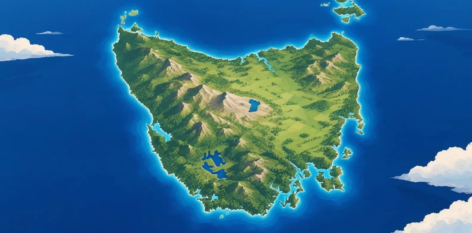
Published
Tasmania key facts
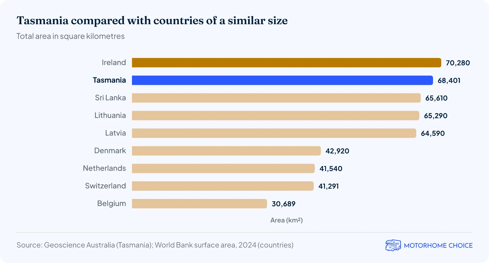
- Area: 68,401 km², 0.9% of Australia1.
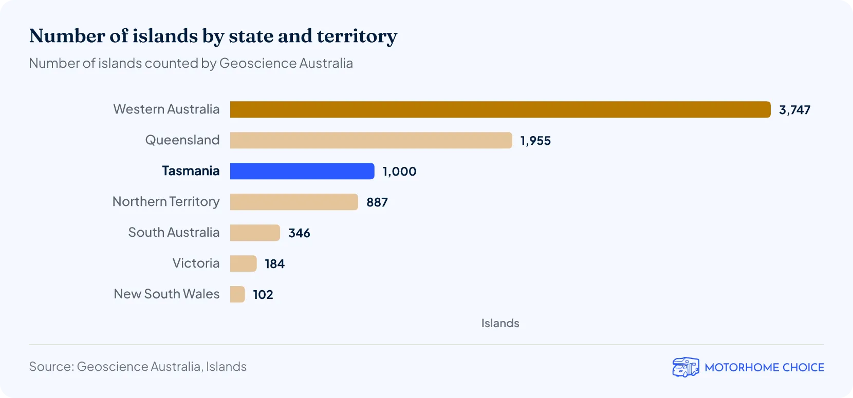
- Islands: about 1,000, the third-most of any state after Western Australia and Queensland2.
- Coastline: about 4,900 km, including about 2,800 km around the main island3.
- Highest mountain: Mt Ossa, 1,617 metres4.
- Largest islands: Flinders Island, about 1,360 km², and King Island, about 1,090 km²2.
- Deepest lake: Lake St Clair, 163 metres, the deepest in Australia5.
- Protected land: about half of Tasmania (50.4% at 30 June 2025) is in reserves6.
- Wettest year: almost 5,000 mm (5 metres) of rain at Mount Read in 2016 (records to 2021)7.
How big is Tasmania?
How big is Tasmania compared with other countries?
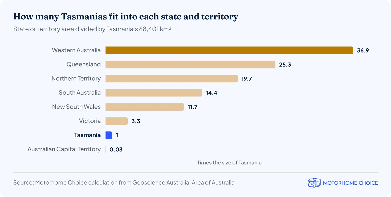
How many Tasmanias fit into Australia?
About 112 Tasmanias would fit into Australia's 7,688,287 km², by our calculation1.
Is Tasmania an island?
Yes. Tasmania is Australia's only island state, and is separated from the mainland by Bass Strait. The state is made up of the main island (64,519 km²) and about 1,000 smaller islands that together add 3,882 km², or 5.7% of its area1.
- Bass Strait is only about 85 metres deep at its deepest point5.
- Tasmania's coastal waters, the belt reaching 3 nautical miles out to sea, cover another 22,357 km²1.
- Macquarie Island, 1,500 km south-east of the main island, is part of Tasmania2. It covers 128 km² and lies 200 km closer to Antarctica than to the rest of the state.
To tour Tasmania by road, you bring a vehicle across Bass Strait on the ferry or hire one after you land: see our guide to motorhome hire in Tasmania.
How many islands does Tasmania have?
Tasmania has about 1,000 islands, the third-highest number of any state or territory after Western Australia (3,747) and Queensland (1,955)2. The count includes small rocks that stay above water at high tide.
- Flinders Island (1,359 km²) and King Island (1,091 km²) are Tasmania's largest offshore islands2. They are Australia's sixth- and seventh-largest islands, not counting the main island of Tasmania.
- Tasmania's islands cover 3,882 km² in total, the fourth-largest island area of any state or territory after the Northern Territory, Queensland and South Australia1.
| Australia's largest islands (over 1,000 km²) | |||
|---|---|---|---|
| Rank | Island | State or territory | Area (km²) |
| 1 | Melville | Northern Territory | 5,786 |
| 2 | Kangaroo | South Australia | 4,416 |
| 3 | Groote Eylandt | Northern Territory | 2,285 |
| 4 | Bathurst | Northern Territory | 1,693 |
| 5 | K'gari | Queensland | 1,653 |
| 6 | Flinders | Tasmania | 1,359 |
| 7 | King | Tasmania | 1,091 |
| 8 | Mornington | Queensland | 1,002 |
How long is Tasmania's coastline?
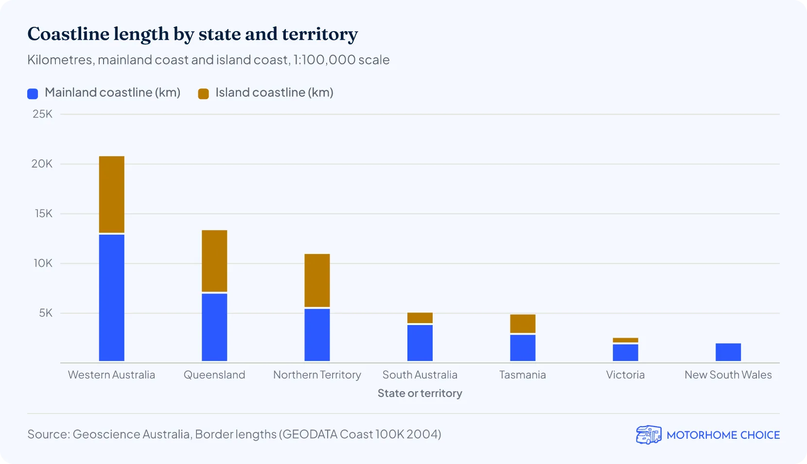
Tasmania's coastline is 4,872 km long: 2,827 km around the main island and 2,046 km around its offshore islands3.
- That is the fifth-longest coastline of any state or territory, behind Western Australia (20,788 km), Queensland (13,352 km), the Northern Territory (10,954 km) and South Australia (5,059 km)3.
- Island shores make up 42% of Tasmania's coastline3.
- Coastline length depends on the map scale. These figures come from 1:100,000-scale maps; a more detailed map traces more bays and headlands, so the total comes out longer3.
What is the highest mountain in Tasmania?
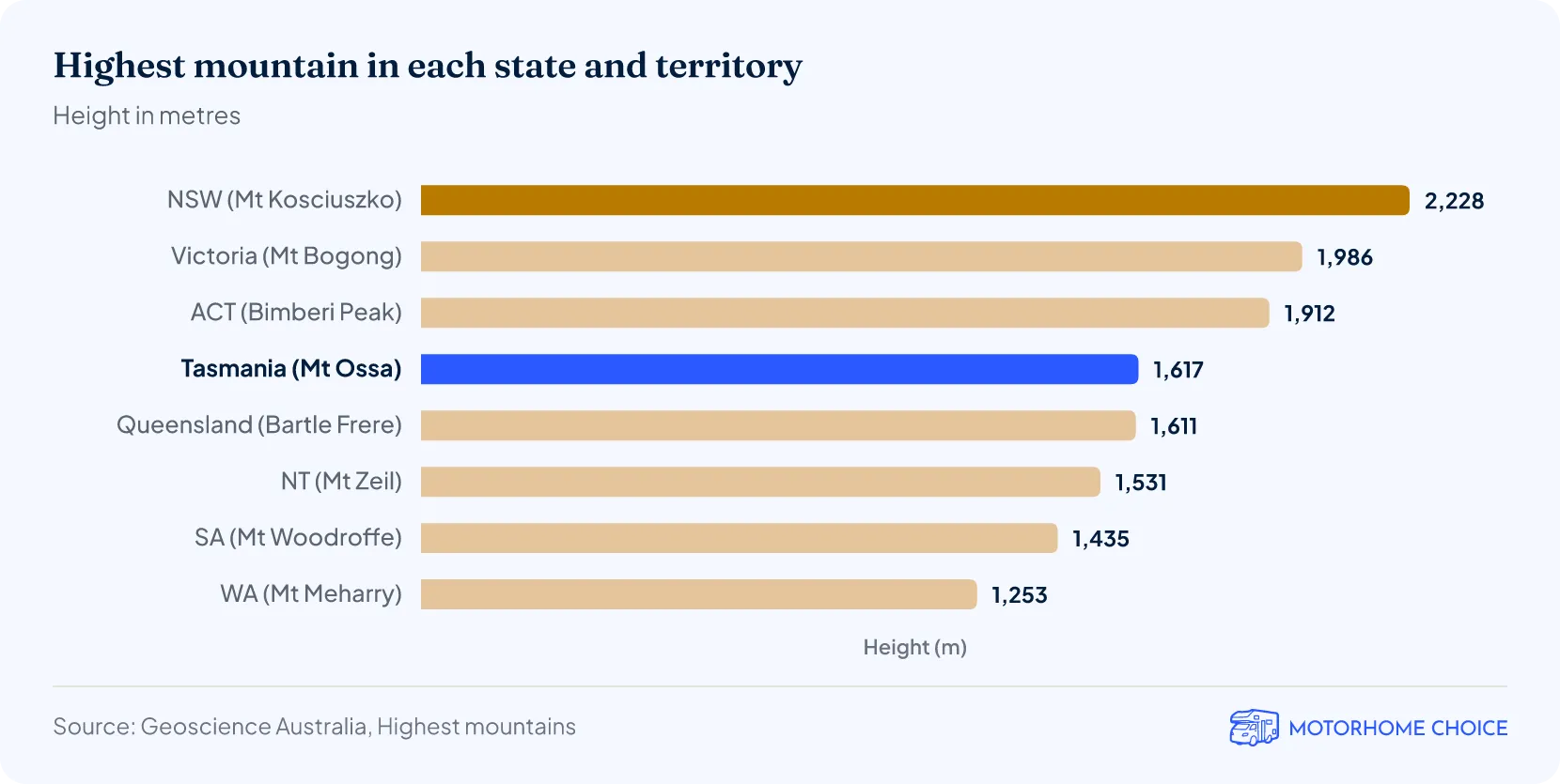
Mt Ossa is Tasmania's highest mountain at 1,617 metres4.
What is the largest lake in Tasmania?
Lake Gordon is Tasmania's largest lake at 272 km², counting reservoirs as lakes9.
- Held back by the Gordon Dam, Lake Gordon can store 12,450 million cubic metres of water, the largest of any state's biggest reservoir, ahead of Lake Argyle in Western Australia (10,760 million m³)9.
How deep is Lake St Clair?
Lake St Clair is 163 metres deep at its deepest point5, CSIRO confirmed in November 2025. That makes it Australia's deepest lake; the next deepest is less than 100 metres deep.
How much of Tasmania is protected?
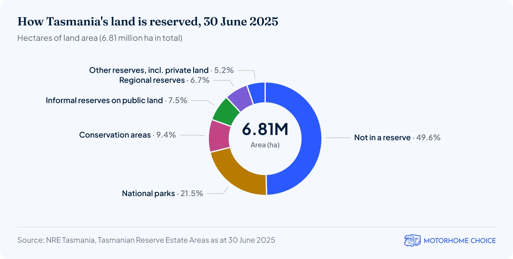
About half of Tasmania is in reserves: 3,433,000 hectares, or 50.4% of the state's land area, as at 30 June 20256.
What are Tasmania's weather records?
Tasmania's hottest recorded temperature is 42.2 °C, at Scamander on 30 January 2009, and its coldest is −14.2 °C, at Liawenee on 7 August 2020, in records to the end of 20217.
- The wettest year on record was 4,998.4 mm at Mount Read in 20167. The Bureau notes the true total is almost certainly higher, because wind, snow and outages affected the gauge.
| Tasmania's weather records | |||
|---|---|---|---|
| Record | Value | Place | Date |
| Highest temperature | 42.2 °C | Scamander | 30 January 2009 |
| Lowest temperature | −14.2 °C | Liawenee | 7 August 2020 |
| Highest daily rainfall | 352.0 mm | St Marys (Cullenswood) | 22 March 1974 |
| Highest monthly rainfall | 984.0 mm | Mount Mawson | October 1988 |
| Highest annual rainfall | 4,998.4 mm | Mount Read | 2016 |
| Highest annual rainfall, manual gauge | 4,504.1 mm | Lake Margaret Dam | 1948 |
More Tasmania facts & statistics
Motorhome and campervan hire in Tasmania
References
- Geoscience Australia, Area of Australia — land areas of states and territoriesga.gov.auPublished 2014-06-27 · Retrieved 2026-10-14
- Geoscience Australia, Islands — largest islands and number of islands by statega.gov.auPublished 2023-11-01 · Retrieved 2026-10-14
- Geoscience Australia, Border lengths — states and territories (coastline lengths)ga.gov.auPublished 2014-07-31 · Retrieved 2026-10-14
- Geoscience Australia, Highest mountains — highest mountain by state and territoryga.gov.auPublished 2014-06-27 · Retrieved 2026-10-14
- CSIRO, Mapping confirms Lake St Clair is Australia's deepest lake, November 2025csiro.auPublished 2025-11-14 · Retrieved 2026-10-14
- Bureau of Meteorology, Australia climate extremes (records to 31 December 2021)bom.gov.auRetrieved 2026-10-14
- Geoscience Australia, Largest waterbodies — largest lakes by state and territoryga.gov.auPublished 2014-06-27 · Retrieved 2026-10-14