

Published
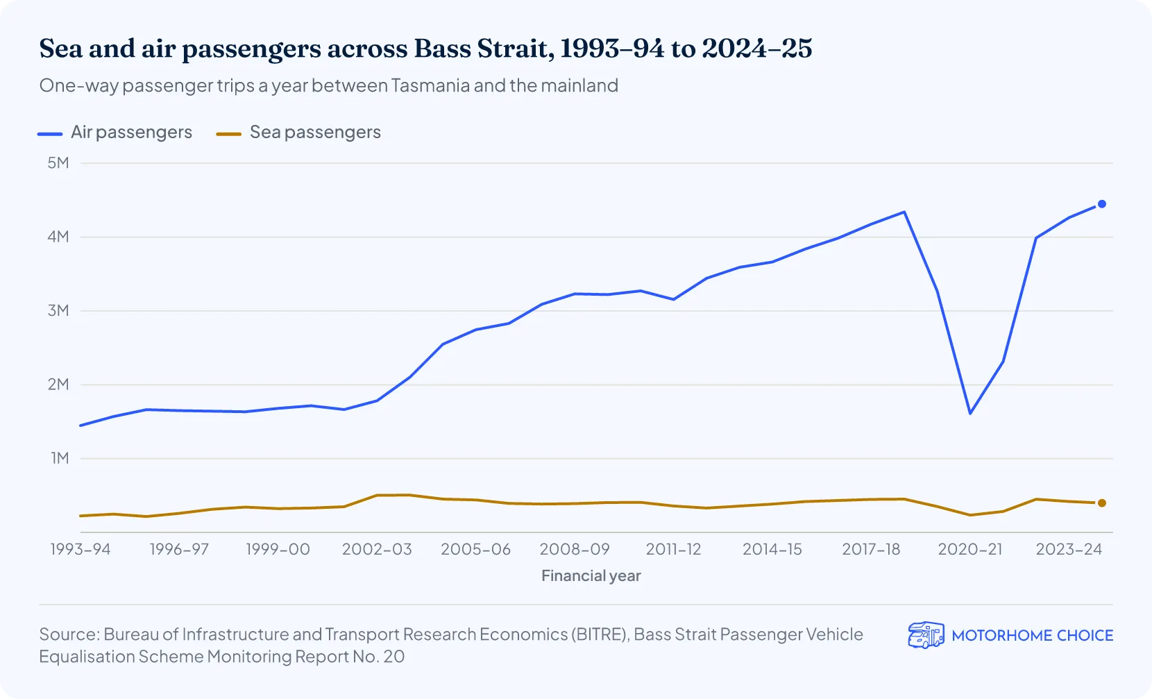
Bass Strait is about 500 kilometres long and averages just 60 metres deep, according to Geoscience Australia (2005)1. Its central basin bottoms out at about 83 metres, and CSIRO gives its maximum depth as about 85 metres (2025)2. In 2024–25, about 400,000 one-way ferry passengers and 4.45 million air passengers crossed it, according to BITRE (July 2026)3.
Bass Strait key facts
- Size: about 500 km long and 350 km wide1.
- Depth: 60 m on average; about 83 m at the deepest point of the central basin1.
- Deepest hole: about 155 m (85 fathoms) in a tidal scour channel north of Flinders Island (1959)4.
- Islands: 52 in the Furneaux Group alone5; Flinders Island (about 1,360 km²) is the largest6.
- Shipwrecks: 258 recorded in the Tasmanian Bass Strait regions of the national shipwreck database, 1797–1998 (our count, October 2026)7.
- Worst disaster: 400 lives lost when the Cataraqui was wrecked on King Island on 4 August 18458.
- Crossings: 4.85 million one-way passenger trips by sea and air in 2024–253.
- Oil and gas: more than 5 billion barrels of oil and 11 trillion cubic feet of gas sold since production began in 1969 (2026)9.
How deep is Bass Strait?
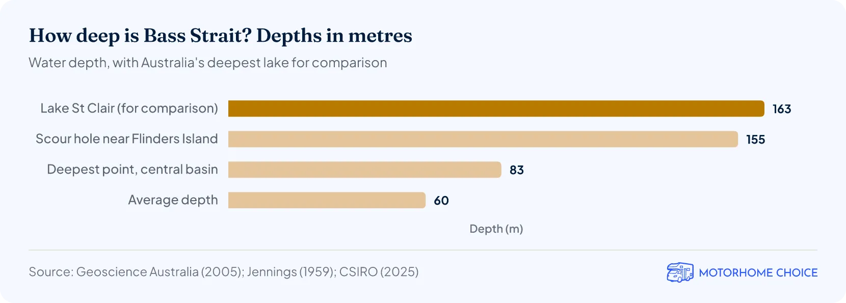
Bass Strait averages 60 metres deep, according to Geoscience Australia1 and the federal environment department10.
The deepest part of the main strait is the Bass Basin, a shallow depression about 120 km wide and 400 km long in its centre, with a maximum depth of 83 m near its geographic centre1. CSIRO gives the strait's maximum depth as about 85 metres (2025)2, and a 2002 CSIRO survey for Environment Australia described a 90 m deep basin in the middle, surrounded by a broad ring about 80 m deep11. Shallower rises at each end, the King Island Rise in the west and the Bassian Rise in the east, separate the basin from the open ocean; both are less than 50 m deep1.
Deeper holes exist, but they are narrow channels scoured by tidal currents between islands. In 1959 geographer J.N. Jennings described the deepest of them, north of Flinders Island, where the western deep reaches 85 fathoms (about 155 metres)4. He noted that the deepest holes usually lie at the narrowest points between the islands. That is why sources quote both about 85 m and about 155 m for the strait's depth: the first is the floor of the open strait, the second a local scour hole.
How wide and how long is Bass Strait?
How many islands are in Bass Strait?
The Furneaux Group alone, at the eastern end of Bass Strait, has 52 islands, according to Flinders Council5, and the Hunter Group in the west has 12 islands and rock stacks13. For the whole state, Geoscience Australia counts about 1,000 islands6.
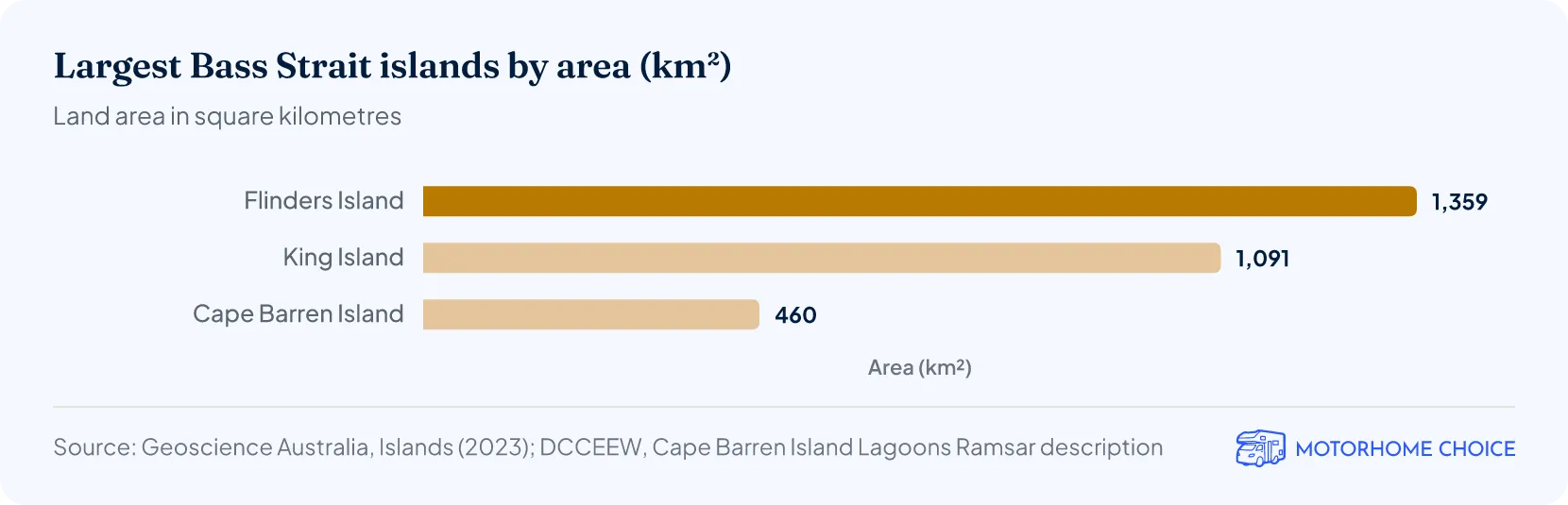
Flinders Island (1,359 km²) and King Island (1,091 km²) are Tasmania's two largest offshore islands, according to Geoscience Australia6. Cape Barren Island, just south of Flinders Island, covers 460 km²14. At the 2021 Census, the King Island council area had 1,617 residents15 and the Flinders council area, which covers the Furneaux Group including Cape Barren Island, had 92216.
| Main Bass Strait islands: area and population | |||
|---|---|---|---|
| Island | Group | Area (km²) | Council area population (2021 Census) |
| Flinders Island | Furneaux Group, eastern Bass Strait | 1,3596 | 922 (Flinders council area)16 |
| King Island | Western Bass Strait | 1,0916 | 1,617 (King Island council area)15 |
| Cape Barren Island | Furneaux Group, eastern Bass Strait | 46014 | Included in Flinders council area |
Source · Geoscience Australia, Islands (2023); DCCEEW, Cape Barren Island Lagoons Ramsar description; ABS, 2021 Census QuickStats.
How was Bass Strait formed?
Bass Strait was dry land, the Bassian Plain, during the last ice age, and the sea flooded it as the ice melted. Flinders Council's history timeline puts the flooding of the land bridge at 15,000 to 10,000 years ago17. Archaeologist Sandra Bowdler (2015) writes that Tasmanian Aboriginal people were cut off from their nearest neighbours in south-eastern Australia for some 12,000 years18.
Who was Bass Strait named after?
Bass Strait is named after George Bass. With Matthew Flinders, he sailed the sloop Norfolk around Van Diemen's Land from 7 October 1798 to 12 January 1799, proving it was an island, according to the Australian Dictionary of Biography19. Flinders wrote in 1814 that Governor Hunter named the strait on his recommendation, as a tribute to his friend and companion20.
Why is Bass Strait so dangerous?
Bass Strait is dangerous because it is shallow, exposed to strong westerly weather, and swept by strong tides. The Bureau of Meteorology calls it a notorious stretch of water between Victoria and Tasmania, where extreme waves are common and opposing tidal currents can make them steeper21. Jennings, citing the Admiralty's Australia Pilot, described strong tidal currents, reinforced by westerly winds, with speeds of 5–6 knots4.
Its many islands, reefs and rocks add to the risk: King Island alone has more than 60 known wrecks22.
How many shipwrecks are in Bass Strait?
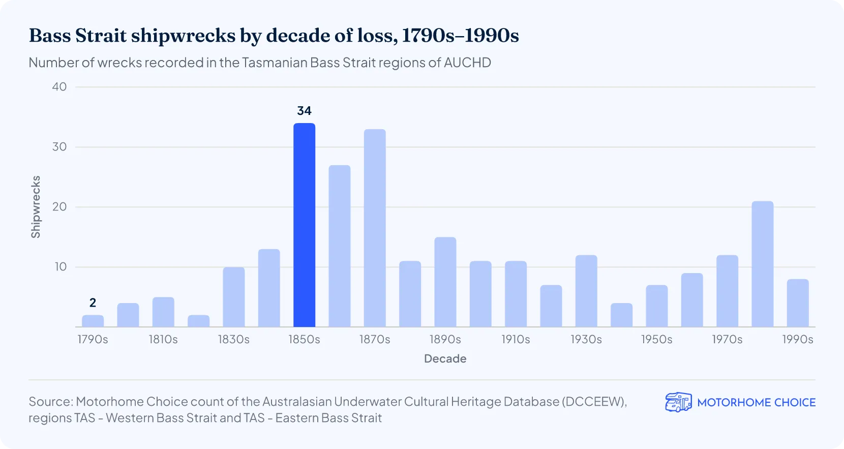
At least 258 shipwrecks are recorded in the Tasmanian Bass Strait regions of the Australasian Underwater Cultural Heritage Database, by our count on 14 October 20267. They span 1797 to 1998. The 1850s had the most wrecks: 34. Of the 258, 156 (60%) were lost before 1900.
The total depends on where the strait's edge is drawn. These regions cover King Island, the Hunter and Furneaux groups and the waters around them, but not Victoria's Bass Strait coast. Counting database records with locations inside an approximate boundary for the whole strait, both shores included, we estimate about 800 wrecks.
The earliest recorded wreck is the Sydney Cove, run aground off Preservation Island in the Furneaux Group on 9 February 1797 after springing a leak23. The deadliest is the emigrant ship Cataraqui, wrecked on King Island on 4 August 1845: of the 409 people on board, only nine survived24. The University of Tasmania's Companion to Tasmanian History puts the loss at 400 lives, making it the worst shipping disaster in Tasmanian waters8.
The Companion also says King Island has more known shipwrecks than any other part of Australia22. We count 67 database records that name King Island as the wreck location7.
How many people cross Bass Strait each year?
About 4.85 million one-way passenger trips were made across Bass Strait in 2024–25: 4.45 million by air and 398,814 by sea on the Spirit of Tasmania ferries, according to BITRE (July 2026)3. Sea passengers fell 6.8% in 2023–24 and another 4.9% in 2024–25, while air passengers rose 6.9% and then 4.4%.
By our calculation, the ferry carried 8.2% of all passengers crossing the strait in 2024–25, down from 13.4% in 1993–9425. Ferry numbers jumped in 2002–03, when a two-ferry service between Melbourne and Devonport began3. Both modes fell sharply during the COVID-19 pandemic, bottoming out in 2020–21.
Each of the new Spirit of Tasmania IV and V ships will carry 1,800 passengers, 28.6% more than the current ships, according to BITRE3. Spirit of Tasmania V arrived in Devonport for the first time in September 2026, and the Tasmanian Government expects the first sailing on 31 October 202626.
If you fly in rather than take the ferry, you can pick up a campervan or motorhome on the island with motorhome hire in Tasmania.
How much oil and gas comes from Bass Strait?
The Bass Strait oil and gas fields of the Gippsland Basin have sold more than 11 trillion cubic feet of pipeline gas and more than 5 billion barrels of oil since production began in 1969, according to operator Woodside (2026)9. The joint venture supplies about 40% of east coast gas demand. The Victorian Government puts total gas produced from the Gippsland Basin at about 12.7 trillion cubic feet27.
Esso and BHP drilled Australia's first offshore well in Bass Strait in 196528. NOPSEMA, the offshore safety regulator, lists 23 offshore platforms and installations in Bass Strait, built between the 1960s and the 2010s29. Woodside took over as operator from Esso on 1 July 2026, without a change in ownership30.
Platforms that no longer produce are being prepared for removal. Esso's 2025 progress report lists 421 wells, 19 platforms, six subsea facilities and more than 800 km of subsea pipeline in the joint venture's Bass Strait assets31. It says platform removal will start no later than 30 September 2027, with some removal work expected from the fourth quarter of 2026.
| Bass Strait oil and gas in numbers | ||
|---|---|---|
| Measure | Figure | Source and date |
| First offshore well | 1965 | ExxonMobil, 202428 |
| First production | 1969 | Woodside, 20269 |
| Oil sold since 1969 | Over 5 billion barrels | Woodside, 20269 |
| Pipeline gas sold since 1969 | Over 11 trillion cubic feet | Woodside, 20269 |
| Share of east coast gas demand | About 40% | Woodside, 20269 |
| Platforms and installations built | 23 | NOPSEMA29 |
| Wells / platforms in the 2025 asset list | 421 / 19 | Esso, 2025 report31 |
Source · Woodside; NOPSEMA; Esso Australia; ExxonMobil Australia.
More Tasmania facts & statistics
Motorhome and campervan hire in Tasmania
References
- Geoscience Australia, Harris, P. et al., Geomorphic Features of the Continental Margin of Australia (Geoscience Australia Record 2003/30), 2005dcceew.gov.auPublished 2005-01-01 · Retrieved 2026-10-14
- CSIRO, Mapping confirms Lake St Clair is Australia's deepest lake, November 2025csiro.auPublished 2025-11-14 · Retrieved 2026-10-14
- Bass Strait Passenger Vehicle Equalisation Scheme Monitoring Report No. 20 (July 2026)bitre.gov.auPublished 2026-07-02 · Retrieved 2026-10-14
- Jennings, J.N., The submarine topography of Bass Strait, Proceedings of the Royal Society of Victoria 71(1): 49–72, 1959zenodo.orgPublished 1959-01-01 · Retrieved 2026-10-14
- Geoscience Australia, Islands — largest islands and number of islands by statega.gov.auPublished 2023-11-01 · Retrieved 2026-10-14
- DCCEEW, Australasian Underwater Cultural Heritage Database: shipwreck searchenvironment.gov.auRetrieved 2026-10-14
- University of Tasmania, Cataraqui, The Companion to Tasmanian History, 2006utas.edu.auPublished 2006-01-01 · Retrieved 2026-10-14
- Department of the Environment, South-east marine region profile, June 2015dcceew.gov.auPublished 2015-06-01 · Retrieved 2026-10-14
- CSIRO Marine Research, Butler, A. et al., Assessment of the conservation values of the Bass Strait sponge beds area (report to Environment Australia), December 2002dcceew.gov.auPublished 2002-12-01 · Retrieved 2026-10-14
- Spirit of Tasmania (TT-Line), How long does the trip take?spiritoftasmania.com.auRetrieved 2026-10-14
- Tasmanian Department of Natural Resources and Environment, Three Hummock Island survey report, 2006nre.tas.gov.auPublished 2006-01-01 · Retrieved 2026-10-14
- DCCEEW, East Coast Cape Barren Island Lagoons Ramsar Site: Ecological Character Descriptiondcceew.gov.auRetrieved 2026-10-14
- Australian Bureau of Statistics, 2021 Census QuickStats: King Island (LGA63410)Australian Bureau of StatisticsPublished 2022-01-01 · Retrieved 2026-10-14
- Australian Bureau of Statistics, 2021 Census QuickStats: Flinders (Tas.) (LGA62010)Australian Bureau of StatisticsPublished 2022-01-01 · Retrieved 2026-10-14
- Bowdler, S., The Bass Strait Islands revisited, Quaternary International, 2015sciencedirect.comPublished 2015-01-01 · Retrieved 2026-10-14
- Australian Dictionary of Biography, Flinders, Matthew (1774–1814), 1966adb.anu.edu.auPublished 1966-01-01 · Retrieved 2026-10-14
- Flinders, M., A Voyage to Terra Australis, Volume 1, 1814 (Project Gutenberg edition)gutenberg.orgPublished 1814-01-01 · Retrieved 2026-10-14
- University of Tasmania, King Island, The Companion to Tasmanian History, 2006utas.edu.auPublished 2006-01-01 · Retrieved 2026-10-14
- Bass Strait Passenger Vehicle Equalisation Scheme Monitoring Report No. 20 — figures workbook (July 2026)bitre.gov.auPublished 2026-07-02 · Retrieved 2026-10-14
- Tasmanian Government, First time arrival into Tasmanian home port for Spirit of Tasmania V, 27 September 2026premier.tas.gov.auPublished 2026-09-27 · Retrieved 2026-10-14
- ExxonMobil Australia, Ensuring ongoing energy security from the Gippsland Basin (speech), 26 March 2024corporate.exxonmobil.comPublished 2024-03-26 · Retrieved 2026-10-14
- Woodside Energy, Woodside completes Gippsland Basin operatorship transition, 1 July 2026woodside.comPublished 2026-07-01 · Retrieved 2026-10-14
- Esso Australia, GD 817 Decommissioning Progress Report 2025woodside.comPublished 2026-01-01 · Retrieved 2026-10-14